Sunday 31 August 2008

Saturday 30 August 2008

Q

I've broken an unwritten rule here. I want my letters to be seperate. For example, If there is a "D" shaped bit of road that is attached to another road, I'm not going to use it. I won't use "S" shaped oxbows in a river for the same reason.

But I really like this Q. It's a spectacular thing for sure. Can you work out what it is?

If you're unable to work it out, click on the google earth link and zoom out a bit.

54°33'30.54"N, 2° 6'52.52"W

That puts it in County Durham, England, in the Northern Pennines just in case you were wondering.

This Q means that I now have about a third of the upper case alphabet, one thirteenth of the lower case alphabet, and none of the numbers, although that will change in the next few days.

abcdefghijklmnopqrstuvwxyz
ABCDEFGHIJKLMNOPQRSTUVWXYZ
1234567890

In the pipeline...

Quite literally in one case.

The letter "Q", the number "8" and lots of funny shaped fields.

Bet you can hardly wait...

Friday 29 August 2008

V

Where would we be without V's?

Geese would have to fly in higgledy-piggledy skeins. Churchill would have stuck two fingers up and it would have been II for IIictory. Mullet headed rock guitarists the world over would be strutting around with Flying Q guitars.

But fortunately, I've found a big capital V. Not only is it big, but it's yellow as well. How did it take so long to find it?

56°14'12.82"N, 9°18'18.41"E

Next time you're flying over Jutland, a little south of Viborg, have a look out of your window and it will be there. It probably glows in the dark.

abcdefghijklmnopqrstuvwxyz
ABCDEFGHIJKLMNOPQRSTUVWXYZ
1234567890

Thursday 28 August 2008

MIAOW!


A

One night in Bangkok makes a grown man tremble.

But that's because he has a variant of Triskaidecaphobia. He's got a fear of Upper Case A's. And there's a bloody enourmous one right smack bang in the middle of Bangkok.

Here it is...

You can see a field on the left of the picture. Just over that field is a big golden temple thing. One of the highest temples in Buddhism. It's called Yuwarajarangsarit Rajaworamahavihara. Yuwarajarangsarit Rajaworamahavihara university is located within it. I don't know what the big grey "A" houses, but those long words are just groovy.


13°45'15.24"N, 100°29'41.71"E

And that's about all I have to say for this post.

abcdefghijklmnopqrstuvwxyz
ABCDEFGHIJKLMNOPQRSTUVWXYZ
1234567890


Wednesday 27 August 2008

T

With curlicues!


Posh huh?

Never mind your common and garden, bog standard, unadorned T's. If you're going to have a T, make it calligraphic, with scrolls.

This T was one of three, but it was the most exclusive of the three.

It's in between Darlton, Nottinghamshire and Saxilby, Lincolnshire. I don't know precisely which country you would find this T in.

53°15'40.06"N, 0°45'35.45"W

abcdefghijklmnopqrstuvwxyz
ABCDEFGHIJKLMNOPQRSTUVWXYZ
1234567890


Portrait gallery

I'm looking for interesting stuff, and every so often I find something that catches my eye and can lead to me looking for other examples.

But in this case, what inspired me was not on Earth at all, but on Mars.

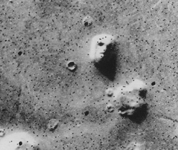
A human head was found on Mars!

Well sort of... A rock formation was photographed by the Viking Orbiter and it looked like a face.

NASA know about such things. You can read what they have to say about this Martian face,

>>> HERE <<<

Well I'm pleased to say, I've found a face in the bleak tundra of Siberia.


71° 4'29.98"N, 76° 7'34.33"E


Looks like a bit of a Goth to me. A bit anaemic. Know what I mean?

So I thought I'd cheer him up a bit.

Hey! Siberian face... An Englishman, a Scotsman and a Russian walk into a bar. The barman says "What is this? Some kind of joke?"


There you go. Works every time.


Monday 25 August 2008

10 CC

See this C? Si?


Well I'm not totally happy with it. It's graphically and geographically too similar to my "E".

So I do have another couple lined up. But which to choose???


28°26'21.70"N, 80°34'42.83"W

This one is a few miles north from the original C. It's part of the original Cape Canaveral spaceport complex and appears to surround a rusty aeroplane. (An F86 Sabre by the looks of things) It reminds me of the circle of stones you'd use to surround a campfire. Perhaps it is. That would explain why the aeroplane is rusty.

The other one I've found is in Dunkirk, France.


I prefer them both to the original. Perhaps one could be "C" and the other, "c".

We'll see.


51° 2'20.59"N, 2°22'43.21"E


Sunday 24 August 2008

A Personal ritual

I got married on 18th of April, 2004. Exactly one year later, me and my lovely missus climbed Helsby Hill and carved our names into the sandstone, before going on to a place called Lady Hayes in nearby Frodsham. That's a big craft centre, and since the first anniversary is represented by paper, it seemed like a good thing to do.

Climbing the hill has become a little ritual. After we've carved the latest date and recut the old cuts, we go driving and find somewhere nice to have a meal.

53°16'24.45"N, 2°45'47.83"W

Helsby Hill is a lovely place to be. The GE screenshot doesn't really do it justice.


You can see up to Liverpool, and across to the hills of Clywyd, and down across the Cheshire plain to the hills of Shropshire. What the picture doesn't show you is the plume of smog from the chemical plants and oil refineries of Ellesmere Port. Nor does it give any indication of the constant muted roar of traffic travelling along the nearby M56 motorway. Oh, and it's generally a bit chilly when the sun isn't shining, at least in mid April. Will we be there next year? If we still have legs, sure!

Already a day out of date...


I love to see cooling towers get demolished. They go this funny wobbly shape that to me is the epitome of the word "woebegone". I feel quite sorry for the poor things really.

The familiar curved cooling towers we see are hyperboloid in shape. This gives a lot of structural strength using the minimum of material. The demolition of these particular towers, the 250 foot tall Blackburn Meadows cooling towers, near Sheffield, England caused quite a lot of argument.
53°25'5.62"N, 1°24'22.04"W

Some people thought they were an eyesore. To others, they were a local landmark. They stood for many years after the rest of the power station that they served had been demolished. This was due to their proximity to the Tinsley viaduct, which carries the M1 motorway past the area. The viaduct has been strengthened over the last few years, and this allowed E-on, who owned the towers, to proceed with the demolition.

The demolition was not a total success. Once the dust had settled, it became apparent that part of the north tower remained standing. It collapsed in on itself a few hours later.

The towers live on though, in Google Earth, and are likely to do so for quite some time.


Saturday 23 August 2008

j

Different letters pose different challenges. "K" for example, is going to be really hard to find, while the problem with "O" is what particular O of the thousands of roundabouts, pergolas, pagodas, irrigated fields, silos, etc, to choose.

I thought j would be difficult, but I found one amidst the sands of Iraq.


There are loads of small (but perfectly formed "U"'s in the vicinity too, but I want all the letters to look different if possible, and U should be fairly commonplace.

The "j" is here by the way...
30°23'48.63"N, 48° 4'43.02"E

abcdefghijklmnopqrstuvwxyz
ABCDEFGHIJKLMNOPQRSTUVWXYZ
1234567890


Friday 22 August 2008

i

i think it's time i did a few things for the first time.

First lower case letter.

First naturally formed letter.

And first letter to have been discovered using literature as a source of inspiration.

Scottish author, Iain (look at all those 'i's in his name!) Banks once wrote a story called "Walking on glass". It featured a paranoid and delusional person called Stephen Grout. Grout is convinced that he's really from another planet, and that he must find clues in the world around him in order to get back home. One promising lead, at least to his mind, is the island of Celebes, in the Indonesian archepalago. He thinks it looks like a character in an alien alphabet. It looks more like an octopus to me, but nearby are a small island - Pulau Balobaloang-besar, and another even smaller, round island - Pulau Balobaloang Ketil. Toghether they form a lower case "i"

They form a part of the Sabalana Islands. They seem to be low islands and they lie between Celebes and Bali.

6°36'6.90"S, 118°52'20.48"E


abcdefghijklmnopqrstuvwxyz
ABCDEFGHIJKLMNOPQRSTUVWXYZ
1234567890

G

It's like a big long episode of Sesame Street. This post was brought to you by the letter G.

It's in Paris, France.

48°50'57.17"N, 2°24'21.14"E

Not a swimming pool in sight. Just copper-clad roofs, or is that rooves?

abcdefghijklmnopqrstuvwxyz
ABCDEFGHIJKLMNOPQRSTUVWXYZ
1234567890


cex!

I just had to! My aim in creating this alphabet is to make a sort of pictorial font. My vocabulary is a bit limited right now, but perhaps at some point I will be able to do a complete post using pictures of letters found on the planet's surface.


E

Right next to C...

This one is also at Cape Canaveral. Is that another swimming pool near the top bit???

Now that's just greedy!

See it for yourself, and how close it it so the C by clicking here...

28°21'9.92"N, 80°36'19.99"W

abcdefghijklmnopqrstuvwxyz
ABCDEFGHIJKLMNOPQRSTUVWXYZ
1234567890


C

What is it with Spaceports?

C is for Cape. C is for Canaveral!

A building enclosing a swimming pool, no less. Those astronauts must get pretty sweaty in those heavy suits.

28°21'16.19"N, 80°36'19.13"W

Just as with the previous entry, this is an upper case C for now.

You want to see the C?

Here it is...


abcdefghijklmnopqrstuvwxyz
ABCDEFGHIJKLMNOPQRSTUVWXYZ
1234567890


X

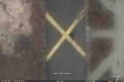
Now this is exactly the sort of thing I was looking for!

A single identifiable letter, big enough to be shown without being all blocky. My computer is playing up a bit and photoshop wont save for web, so I've turned the quality down a bit on the image, but it's still as good as I wanted it to be. It's an upper case X because... well because that's what it looks like to me. If I find a better X it might be used as a x instead.

This letter is on a patch of tarmac at Vandenberg air force base. It says, "Don't land here!"

34°45'32.98"N, 120°33'12.35"W


Here it is.


Kiss it!

abcdefghijklmnopqrstuvwxyz
ABCDEFGHIJKLMNOPQRSTUVWXYZ
1234567890


Wednesday 20 August 2008

Links...

I've been trying to find a way of posting links to locations that will open up google earth at that location.

Saving the kmz files to some place within blogger would have been nice, and googlesites is really too unwieldy for what I wanted, but freewebs seems to do what I need.

So clicking on >>> this link <<< should open up google earth and take you to an airport on an island in the middle of the Atlantic. The same place I failed to land at yesterday.


What all the fuss is about.

You can get google earth by clicking


Google Earth is basically a huge montage of aerial and satellite photographs overlaid onto a sphere. You can move around, zoom in and out, and the terrain rises and falls on the globe to create mountains and valleys etc. Because it's like sticking photograhphs onto a globe, what you get is a slightly impressionistic view of the world, particularly when flying around. Trees don't stick up. They are flush with the terrain for example, but overall the effect can be spectacular. Many areas, particularly in less developed parts of the world, are pretty low resolution, taken from space, and not particularly detailed.


Here's an example taken from roughly a kilometre above ground level. ( 54°37'22.40"N, 89°24'9.29"E) It's near Chërnoye Ozero in Russia apparently.

A few years ago, more of the map was like this, but google are gradually replacing satellite imagery with much higer resolution aerial photography...


Like this image of Derwent Water in the Cumbria, England. Also taken from about a kilometre above the ground. The co-ordinates for this one are ( 54°34'56.56"N, 3° 7'58.34"W) by the way.

Clicking on either of the pictures will open full sized versions. Obviously the level of detail is much higher using aeroplanes than it is using satellites. High enough to make out cars, people, even sheep in fields. This has led to concerns about security and privacy. Generally google have complied with governmental requests not to use hi res pictures of sensitive areas.

Google earth contains optional layers, often created by its' userbase. You can click on webcams, hi res panoramic photographs, layers highlighting environmental concerns, such as boxes giving emissions data for large factories. Most of these layers will have just a few icons on the globe, but clicking on them gives you the option of showing them all. Clicking on the boxes these open in google earth will often open up a webpage in your browser of choice, giving you further information and links to other similar things.

Most options can be toggled on and off by using the sidebar on the left. This too can be toggled on and off to give you a full screen display, or a mixture of display and options.

There's much more to it, but that'll do for now.


Tuesday 19 August 2008

I landed safely at Liverpool airport!


I somehow taxied onto the southern runway at Manchester Airport ( 53°21'7.80"N, 53°21'7.80"N)

Via the grass...

Took off... Went too far south. Found a city. This turned out to be Chester, but I thought it was Wigan or St Helens. But anyway, I recognised the canalised bit of the River Dee. I used to work nearby.

From there I was able to follow the A550 towards Ellesmere Port, and circle round a bit over the Mersey until I found the runway. And I landed it without crashing. On the grass. But it did finish on the runway. ( 53°20'0.65"N, 2°51'5.76"W)

Progress!!!!!