Showing posts with label walking. Show all posts

Thursday, 7 October 2010

Moel Famau


(click for bigger size. same applies for all the images below too)

Let's start at the beginning shall we? A week or two ago, seeing the dawn from the top of Moel Famau was mentioned in conversation, along with "How cool would that be?"

I wanted to go a week or so ago, but Bren had other committments, so we settled on this morning instead.

As the day approached I anxiously checked the weather forecast, and yesterday evening, the forecast for Mold reckoned the night would be clear, and the day would be sunny.

Good omens!

And so we got up at 4.30 4.40 this morning with a struggle, intending to leave the house at around 5am.

And so it was that at 5.30 am, we set off for Flintshire.

Moel Famau is the tallest of the Clywyd hills. It stands at around 1,800 feet tall, and offers a fine view in all directions. You can see it from most of wirral, where it looks like a sort of volcano with a pimple on the top. Here's how it looks from Google Earth.


A late start and a wrong turn meant that by the time we arrived at around 6.20, the sky was starting to lighten in the East. We parked in the car park, put our boots on, and started walking.

Moel Famau is a popular and straightforward climb. There is a well defined path running up to the summit from the car park, and the strengthening light meant we were able to find our way without trouble. Driving in the dark for the previous hour had sharpened our night vision, so the first few photos I took were far darker than what we could see with our eyes.


As we got towards the top, we met a man coming down with a camera and tripod. And here's me thinking we were the only ones! I wonder what kind of pictures he managed to take? As you can see, the sky is much lighter. We'd missed the dawn by maybe half an hour.


But we didn't really go up to see the dawn at all. The dawn is just the sky gradually turning from black to blue to red. It's like the bit after sunset where the sky gets duller, only backwards.

No, we weren't there to see the dawn. We were there to see the sunrise!

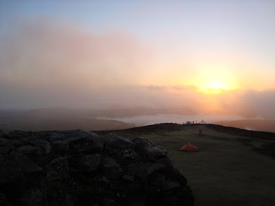
The view was amazing. Thick mists were rolling across the fields below. At first the summit was clear, but we found ourselves surrounded by thin cloud that fogged up Brenda's lens, and softened our view of the surrounding countryside. And as this happened, the sun rose above the horizon.

We drank cocoa and I smoked a cigarette. But mainly, we took photographs. Lots of photographs.

Sun and mist gave rise to something called a brocken spectre. Something I've never seen with my own eyes before. The good thing about them is that everyone gets one for themselves.

The Brocken Spectre appears when a low sun is behind a climber who is looking downwards into mist from a ridge or peak. The "spectre" is the shadowy figure - the glow and rings are of course a glory centered directly opposite the sun at the antisolar point. But how is the ghostly figure produced? It is no more than the shadow of the climber projected forward through the mist. All shadows converge towards the antisolar point where the glory also shines.


But enough words.


This is just a brief selection of the better ones I took at the top.

Here are some more from on the way down.


Today was a day I will remember for the rest of my life.

For the photographically minded, the photographs above were taken using a Sony Cybershot 7.2 Mp camera, using either "Easy" or "Auto-adjustment" settings. With the exception of the letterbox format picture at the top of this post, which is a composite created using autostitch, and cropped using gimp, the photographs have not been modified or processed in any way.

Monday, 5 April 2010

Cardingmill valley and the long mynd

Out gallivanting today... Church Stretton. After spending time with someone there a week or so ago, I thought it would be a good place to take my wife for a walk. Some lovely roads to drive on. (some terrifying roads from Bren's point of view. one in four descent made to a soundtrack of whimpers! white knuckles against the door grab handle...)

And some gorgeous scenery to see.

We got there early afternoon, and headed up onto the moors. One thing we didn't count on was the wind, which was almost strong enough to blow the sheep over. Went to what appears to be called Cardingmill peak. The wind was incredible. You could lean right back into it and really feel the air supporting you! If I'd unzipped my coat and spread it out, I reckon I might just have taken off.


Pissing in the wind.

When you do piss in the wind, it's best to have the wind behind you and your legs well apart. In a gale, be aware that as soon as it leaves the lee of your body, and gets caught by the airstream, your piss will stop being a steady stream. It will instantly become an atomised spray that can be carried for hundreds of yards. Therefore pissing in the wind is best done with nobody, absolutely nobody, and especially not a big bloke with tatooes on his knuckles, standing downwind of you.

We scrambled down the side of the hills to the valley below. The valley below is a big national trust thing, with a pay and display car park, and a cafĂ© and shop. A cup of tea, a bit of flan, a bowl of soup, 2 slices of cinnamon flapjack, and a yoghurt bar set us back £17. For a good cause I suppose, but pretty bloody steep, just the same.

Talking of steep, the way back up the road to the car was indeed, steep. It was much less scary on foot than it was driving. But more strenuous.

We saw a bloody enormous bird of prey, that I reckon might have been a Red Kite, and when we got back to the car, it started pouring with rain, if you can call something horizontal, "pouring", so perfect timing there! Hurrah!

Tuesday, 9 March 2010

The bigger picture


  • The Great British Public get ready for the general election

For some reason, if I try to copy an image from google earth, and paste it into a photo editing program (I use a thing called GIMP, which is an open source photoshoppy thing) it says there is no image data in my paste buffer.

Trying for a workround, I found that I could email the image to myself, then copy the image and paste it.

What I'm trying to do is create an enormously wide picture by stitching several images together.

A bit time consuming but should be relatively straightforward.

You'll see the result at the bottom of this post, assuming I can work it out.

Today, we went for a walk along the Dee marshes. In a similar vein to the walk we did a few weeks ago in Mostyn in North Wales, but this time, I found that we could walk along the old road past the firing range. There's no vehicular access, but you are allowed to walk.

There was a big red flag flying, but that's always there. As I mentioned last time, the road has been closed to vehicles for getting on for 20 years, and I was interested to see how it had deteriorated. It was actually in fairly good nick, considering. I think perhaps the sheep help to keep the grass and weeds from taking hold. Or maybe the fact that it's nothing more than the occasional tractor driving along it has something to do with it.


The ravages of time do show up in some things though.


We went just a little bit past Burton Point, where there used to be an Iron Age settlement. There are spectacular views across the marsh to the Clywydian hills. Surely Moel Famau is a mother mountain if ever there was one. Today it was in silhouette, because we got there as the last dregs of daylight turned everything red and gold.


As to that big pic? Still trying to sort it out. It involves layers, and it's getting too complicated for my tired brain.

Wednesday, 17 February 2010

Walking for fitness and pleasure.

I'm getting a bit of a belly on me.

A combination of a sedentary job, followed by evenings spent surfing the net, and an unhealthy diet are causing me to gain weight. Or to be more precise, mass.

The diet never used to be a problem (at least not to my body mass index. I'm sure my arteries are furring up nicely.) because I used to cycle and walk everywhere.

I've always enjoyed the great outdoors. I love wildernesses as long as theyr'e relatively free of tigers, mosquitoes and nettles. And wasps. So today, being a day without any work to do, I went for a walk.

I was going to go to the Deeside marshes and walk down to Burton Point, but that's dodgy ground these days. Has been for quite a few years in fact. You used to be able to drive along this narrow, rutted little road. Covered in weeds and sheep shit, it was. But it ran right next to an army firing range. They closed the road off about 15 years ago, although I suppose you could climb over the fence and walk along it. I suspect there's even more weeds and sheepshit now. When I first got wheels, in my mid 20's, I'd be down there regularly, whizzing along over the cattle grids, listening to mix tapes and getting stoned.

Back to the present day though, and rather than risk getting shot or told off or arrested, I looked for somewhere better, on Google Earth, and found the old fun ship near Mostyn on the Flintshire coast. That lies next to a public footpath that runs alongside the Dee estuary.

Bingo!

The path has to leave the riverside after a mile or so, because industry intervenes. There's a wind turbine factory, and there's a dock that takes Airbus A380 wings from the barges that brought them from Broughton, and takes them to Toulouse in France. So that's as far as we went.

Some pictures:


This is the "Fun Ship". It's as much fun as standing on a rake. It used to be a ferry, then it got dragged up onto the beach here and turned into an amusement arcade. Now it's used as storage space and it's closed to the public. They are warned of dogs and landmines and the threat of prosecution. Probably best not to try to get in. Fair enough. I can see the vandals would have a field day with it. It's looking more and more decrepit as the years go by, but I'm told it's quite nice inside.


When I took this picture, the late afternoon sunshine was reflecting off the water, and making pretty patterns on the wall. It doesn't show up too well on a still picture though. Never mind. It does give an accurate picture of what the banks of the Dee Estuary are like. The brown stuff is soft thick mud. Ideal for oystercatchers and herons. Not so good for drunks.


This is what the West coast of the Wirral looks like from the Welsh side of the Dee. The line of white buildings towards the right of the picture is a place called Parkgate. They're famous for their icecream.


Sheep. Eating gravel and sawdust. There was a perfectly green and grassy field just a few hundred yards away, but they chose, of their own volition to graze here.


A sewage treatment plant. There are quite a few of these along both banks of the Dee. It didn't smell at all. Birds were feeding off insects on the filter beds, although they kept getting disturbed by the rotary sprayer thing.


In the distance, you can see Hilbre island. It's pronounced "Hill-Bree" and it lies about a mile off the coast of Wirral. My Mum got stranded on it once. She made the BBC news! Behind Hilbre, there's a big load of wind turbines. They're Burbo Bank wind farm and they generate enough energy to power 80,000 homes, although I suppose if everyone plugged their car into a wall socket, this number would shrink somewhat.


The ship that takes the wings of the worlds largest passenger plane to France. And this is as far as we went.

Coming back we saw an incredible sight. There was a huge white cloud boiling up from beyond Wirral. It was coming from Fiddler's Ferry power station. This generates a little over twice what the wind farm generates, but nowhere near as cleanly. Water vapour is itself a greenhouse gas. Putting bloody great clouds into the sky can't be good. I say bollocks to the nimbies. Build turbines. Lots of them.

Sadly, my camera stopped taking pictures. I tried several times but it just wouldn't click it's shutter. I blamed the battery and gave up in disgust.

I found later that I'd somehow moved the dial to video. So here's a short video of the cloud generated by a coal fired power station about 20 miles away.